The system combines a 360-degree prism, IMU, GNSS receiver and automated rod height measurement in one device.
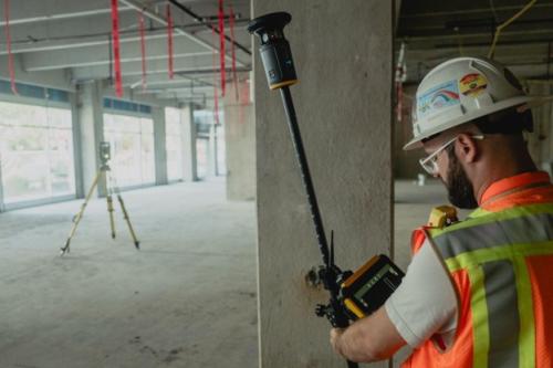
Trimble announced the launch of the Trimble ST30 smart target, a surveying system that combines optical and subscription-based GNSS functionality in a single device. The ST30 includes tilt compensation and automatic rod height measurement. Its integrated GNSS functionality supports both optical and GNSS surveying applications.
The Trimble ST30 smart target will be showcased at INTERGEO 2026, taking place Sept. 15-17, 2026, in Munich, Germany, at Trimble’s booth in Hall B6.
The ST30 is designed for surveying and construction tasks such as topographic surveys, stakeout, as-built verification and cadastral work. It integrates with Trimble field, office and cloud software to support data collection and traceability. Compatible solutions include Trimble S-, RTS- and SPS-series robotic total stations, Trimble Access, Trimble Siteworks, Trimble FieldLink, Trimble Business Center and Trimble Connect.
The ST30 integrates a 360-degree prism, IMU, GNSS receiver and automated rod height measurement in a single device. The smart target uses magnesium and aluminum construction, a protective top bumper and shielded LEDs for use in various jobsite conditions, including wet environments. Features include:
- Adjustable rod height — Automatic rod height measurements help reduce errors associated with manual rod height changes and can reduce related rework.
- Prism accuracy — The 360-degree prism supports measurement workflows requiring millimeter-level precision and can be used with optical surveying applications.
- Tilt compensation — Tilt compensation removes the need for operators to continuously monitor a level bubble. The function supports both total station and GNSS measurements for topographic and stakeout workflows. It also allows measurements of hard-to-access points with a tilted pole, which can reduce instrument setups and manual offset calculations.
- Active tracking and target ID — The smart target uses a three-part tracking system to maintain target lock in different site conditions. Active tracking helps reduce false locks caused by reflective surfaces, while target ID allows the total station to follow an assigned target. Trimble GeoLock GNSS-assisted technology helps regain a lost target lock.
- Integrated GNSS — High-accuracy GNSS functionality will be available through a separate subscription beginning in 2027. It supports surveying workflows at different station setups, including site calibration and control setup, and enables measurements beyond optical line-of-sight limitations.
The Trimble ST30 smart target will be available to order through Trimble’s global dealer network in the fourth quarter of 2026.
For more information about Trimble, visit trimble.com.