Traffic
The elevated Central Artery has just six lanes. The new underground expressway will have eight to ten lanes. Altogether, the CA/T project is building 161 lane miles of highway in a 7.5 mile corridor, about half in tunnels, including four major highway interchanges. The old road has 27 on- and off-ramps; the new one will have just 14. With an improved surface street system, local traffic will get off the main highway and distribute itself on the surface, with through traffic moving more easily through the city. The elevated highway carried about 75,000 vehicles a day comfortably when it opened in 1959. Today it carries more than 190,000, quite uncomfortably. Traffic jams last for eight to ten hours a day, with an accident rate four times the national average for urban interstate. If nothing were done, traffic would be jammed in stop-and-go misery for 15 to 16 hours a day — every waking hour — by 2010. The underground Central Artery will carry about 245,000 vehicles a day by 2010, with the Ted Williams Tunnel carrying about 94,000 vehicles a day. There will be normal urban rush hours of a couple of hours in the morning and evening on the underground expressway, with traffic moving at about 30 mph.
Dirt
 |
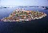
The project will excavate a total of 15 million cubic yards of dirt, enough to fill Foxboro Stadium (where the New England Patriots football team and Revolution soccer team play) to the rim 15 times. About two-thirds of the dirt will be trucked to landfills and other sites. Moving all that dirt will take more than 541,000 truckloads. If all those trucks were lined up end to end, they'd back up 4,612 miles. That's all the way to Brasilia, capital of Brazil, as the crow flies, or to the Panama Canal strictly over land. The rest of the dirt, more than 4,400 barge loads of it, is being taken to Spectacle Island in Boston Harbor, where an old dump has been capped to make way for a new park. About 2.5 million cubic yards of clay will be made available to cities and towns to cap landfills that have reached capacity. For more about what we are digging, see "what are we digging", in the Digging and Dumping Dirt section (in Environmental). |
Concrete and steel
The project will replace all that dirt with 3.8 million cubic yards of concrete, enough to build a sidewalk three feet wide and four inches thick from Boston to San Francisco and back three times. The project will install more than 26,000 linear feet of steel-reinforced concrete slurry walls, which form the walls of the underground highway as well as the supports for the elevated highway during construction. That's five miles of slurry walls, the largest application of this construction technique in North America, all resting on bedrock up to 120 feet below the streets of the city. Reinforcing steel used in the project would make a one-inch steel bar long enough to wrap around the earth at the equator. When the project tears down the elevated Central Artery starting in 2003, it will remove enough structural steel to make five Tobin Bridges.
First, most, biggest
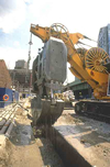
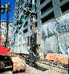
The South Boston connection (or interface) between the underwater section of the Ted Williams Tunnel and the land-based approach was built in the widest and deepest circular cofferdam in North America. A ventilation building was built inside the cofferdam, which is a watertight structure from which water is pumped so that construction can take place inside. The Ted Williams Tunnel interface in East Boston between the land-based approach and the underwater portion is 90 feet below the surface of Boston Harbor, the deepest such connection in North America. The project's seven-building ventilation system will be the largest highway tunnel vent system in the world. Traffic using the Metropolitan Highway System (including the underground Central Artery, the Ted Williams Tunnel, and the Mass Turnpike out to Route 128) will be monitored by the most advanced traffic management and incident response system in the world, including more than 400 video cameras, 130 electronic message signs, 30 infrared height detectors, and six emergency response stations in operation 24 hours a day. Radio and cellular phone signals will be re-broadcast into the tunnels. The project's main Charles River bridge will be the widest cable-stayed bridge in the world, the first to use an asymmetrical design, and the first hybrid design in the United States, using both steel (in the main font) and concrete (in the back fonts). The project includes the largest use of segmental bridge construction and the largest application of steel box girders in the United States. Crossing the Fort Point Channel includes the most extensive use of concrete immersed tube tunnels in the United States, the first installation of jacked vehicle tunnels in North America (and one of the largest in the world), and the second use of soil mix construction on the East Coast (the first use came in East Boston on the Ted Williams Tunnel). The project includes the largest geotechnical investigation, testing and monitoring program in North America. The purpose is to identify conditions in the path of tunneling work, and help prevent buildings from settling during the digging.
Parks and Open Space
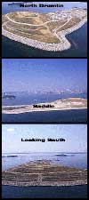
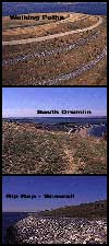
The project will create more than 150 acres of new parks and open space, including 27 acres where the existing elevated highway now stands, 105 acres at Spectacle Island, 40 acres along the Charles River, and 7 acres as part of an expanded Memorial Stadium Park in East Boston. Three quarters of the 27 downtown acres will remain open. The rest will be set aside for modest development, including retail, commercial, and housing uses in low-rise buildings. More than 2,400 trees and 26,000 shrubs will be planted at Spectacle Island. Another 2,400 trees and more than 7,000 shrubs will be planted downtown.
|
Underground Utility Relocation
|
| The project's underground utility relocation program moved 29 miles of gas, electric, telephone, sewer, water, and other utility lines maintained by 31 separate companies. All told, about 5,000 miles of fiber optic cable and 200,000 miles of copper telephone cable will be installed. |
|
Odds and ends
Because of the new highway system, Boston's carbon monoxide levels will drop 12 percent citywide. How can a road carrying more cars reduce pollution? Because it will keep traffic moving, so that emissions will be reduced significantly. The cable-stayed bridge across the Charles River will use 1,820 miles of steel wire to form the seven-wire strands that are in turn bound together to form the support cables, the largest a foot in diameter. About 150 cranes are in use project-wide. The first 25 percent of construction took five years to complete, the second 25 percent took about two years to complete (the halfway point was reached in the spring of 1999). During the peak of construction (1998 through 2000), about $3 million of work is completed each day.
|
At the peak of construction activity, in the year 2000, about 4,000 construction workers will be on the job. The peak of construction's impact on the city came in 1997 and 1998. As concrete decking is placed over the concrete tunnel walls, the frequency of traffic changes will slow until the highway corridor is entirely decked over in 2000. The deepest point of the underground highway is 120 feet down, beneath the Red Line subway tunnel at Dewey Square (Atlantic Avenue and Summer Street). The highest point is at State Street, where the highway passes over the Blue Line subway tunnel and the roof of the highway is the street above. The project includes 109 separate construction contracts. |
The Central Artery/Tunnel project is one of the most extensively reviewed public highway projects under federal and state environmental statutes and regulations. The reviews emphasize construction-period mitigation measures as well as permanent environmental improvements. After the project is complete, Boston and other communities will see important environmental benefits including improved air quality, capped landfills and increased parkland. The environmental review process began in 1982, eight years prior to construction, to meet requirements under both the National Environmental Policy Act (NEPA) and the Massachusetts Environmental Policy Act (MEPA). The first Final Environmental Impact Statement/Report (FEIS/R) was approved in 1985.
|
|
In 1990 a supplemental (FSEIS/R) was approved for the South Boston Haul/Bypass Road. The project wide Final Supplemental Environmental Impact Statement/Report (FSEIS/R) received a certificate from the state Executive Office of Environmental Affairs (EOEA) in January 1991 and its formal approval from the Federal Highway Administration (FHWA), known as the Record of Decision, in May 1991. After receiving the Record of Decision the project was given the green light to begin advertising construction contracts. This 5000-page, 12-volume FSEIS/R weighed in at 44 pounds and was extensively reviewed by agencies and the public, who commented on the document in writing and at public hearings. Later in 1994 a supplemental FSEIS/R specifically for the Charles River Crossing was approved. All these documents and their draft and summary documents are available for review and copying at the Transportation Library at 10 Park Plaza in Boston. In order to authorize and maintain construction, thousands of other federal, state and local environmental permits, licenses and approvals are required. In addition, ongoing environmental review of project changes and permit modifications by the agencies and the public continue.
Digging and dumping dirt not only earned the Central Artery/Tunnel project its nickname "the Big Dig," but presented it with its biggest challenge: How do you safely and appropriately handle more than 15 million cubic yards of dirt? Through the environmental review process, the challenge evolved into plans and later in the mid-1990s into an innovative materials reuse program that has benefited many communities in Massachusetts and some other parts of New England. From 1993 to 1998 more than 4,400 barge loads of dirt were taken to Spectacle Island in Boston Harbor, where an old dump has been capped making way for a new park to open in 2002. About 3 million cubic yards of Boston Blue Clay is being made available to cities and towns to cap landfills that have reached capacity. The clay and other Big Dig soils have contributed to the closure and redevelopment of municipal landfills in Acton, Boston, Foxboro, Middleboro, Middleton, Natick, Needham, Norwood, Plymouth, Raynham, Scituate, Taunton, Walpole, Weymouth, a state-owned landfill in Middleton, and a solid-waste disposal site in Chelmsford; closure of a state-owned landfill in North Andover, the closure of portions of the Central Landfill in Johnston, Rhode Island, and contributed to the closure of landfills in Meriden and New Haven, Connecticut. In addition, more than one million cubic yards of clean dredged clay from construction of the Ted Williams Tunnel have been deposited at the Massachusetts Bay Disposal Site (MBDS), under the supervision of the US Army Corps of Engineers. Finally, about 435,000 cubic yards of contaminated or hazardous soils is being treated and recycled or land filled at properly licensed facilities, mainly located outside of Massachusetts. The project must also remain friendly to the environment during construction. With construction scheduled to last from 1991 to 2004, the economic vitality of the city depends on the project allowing businesses to operate normally, traffic and pedestrians to move comfortably through downtown, and residents to endure as little disruption to their lives as possible. Click to learn more about our mitigation efforts. |
|